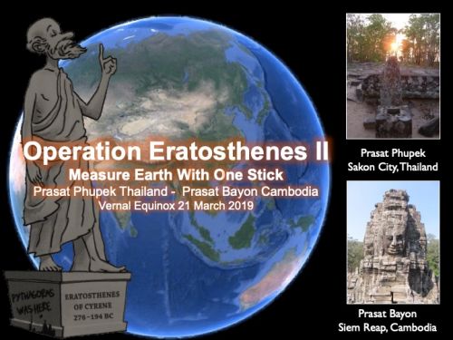
Operation Eratosthenes Episode II
"Mesure Earth's curcumference with one stick"
Vernal Equinox March 21, 2019
Prasat Phupek Sakon Nakhon, Thailand
Prasat Bayon Siem Reap, Cambodia
What is Operation Eratosthenes
Around 100 BC an ancient Greek astronomer named Eratosthenes had invented a methology of how to mesure "Earth's circumference" by using angle of incidence of the sun at solar noon between two places located in north and south of Egypt. Today his innovation is well known among astronomers all over the World, to honored him I would like to repeat his ancient experiment under the title "Operation Eratosthenes"
Background and History
Egypt at the time of Eratosthenes 279 - 194 BC was under Greek political influence called Ptolemaic Kingdom after the death of Alexander the Great in 323 BC. Alexander advanced to Egypt in later 332 BC, where he was regarded as a liberator. He was pronounced son of the deity Amun at oracle of Siwa Oasis in the Libyan desert. Henceforth he often refered to Zeus-Ammon as his true father, and after his death currency depicted him adorned with horns of a ram as a symbol of his divinity. During his stayed in Egypt he founded Alexadria-by-Egypt which become the prosperous capital city of the Ptolemaic Kingdom after his death.
.jpg)
Alexander the Great was repected as Pharoah of Egypt during 332 - 323 BC
Eratosthenes 276 - 194 BC born in an ancient Greek town name Cyrene in Egypt (modern day Shahhat in north-eastern Libya), he is best knownfor being the first person to calculate the circumference of the Earth, which he did by comparing angle of the mid-day at two places a known North-South distance apart, his calculation was remarkably accurate. He calculated the Earth's circumference without leaving Alexandria he knew that at local noon on the summer solstice in Syene (modern Aswan Egypt) the sun was directly overhead (Syene is at latitude 23 - 24 -00 degree North in 100 BC) He knew because the shadow of someone looking down a deep well at that time an Syene blocked the reflection of the sun on the water. He then measured the sun's angle in Alexandria by using a vertical rod known as a gnomon, and measured the lenght of its shadow on the ground using the lenght of the rod and the lenght of the shadow as the leg of a triangle of the sun's rays. This turned out to be about 7 degree or 1/50th the circumference of a circle. Taking the Earth as spherical and knowing direction of Syene he concluded that the Earth's circumference was fifty times that distance
1. The distace between Alexandria and Syene was 5,000 Stadia
2. Alexandria is due north of Syene
3. Syene is on the tropic of Cancer
4. The Earth is a perfect sphere
5. Light ray emanating from the sun are paralell
Eratosthenes later rounded the result to a final value of 700 Stadia per degree, which implies a circumference of 252,000 Stadia. In 2012 Anthony Abreu Mora repeated Eratosthenes's calculation with more accurate data the result was 40,074 Km with is 66 Km different (0.16%) from the currently accepted polar circumference of the Earth 40,008 Km (40,074 Km - 40,008 Km = 66 Km)
.jpg)
A Greek Astronomer "Eratosthenes" 276 - 194 BC

Eratosthenes calculated Earth's circumference by using angle of shadow at Alexandria and Syene
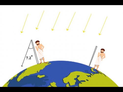
Eratosthenes observed that the angle of incidence (sun's rays) on solar noon at Alexandria is 7.2 degree but at Syene the sun is overhead
.jpg)
On the day of summer solstice, sun is overhead at Syene but at Alexandria the angle of incidence is 7.2 degree
First Operation Eratosthenes 2012
Measure Earth's cicumference with one stick
Eratosthenes's method is repeated after 2,000 years by my colleagues and I, we are organized into two working units known as "Team A" operate at an ancient Khmer Temple named "Prasat Phupek" in Sakon Nakhon Province northeast of Thailand and "Team B" operate at a well known ancient Khmer Temple known as "Prasat Bayon" in Angkor Thom Siem Reap Province Cambodia
The reason of choosing these two places are
1. The two temples are located in direction of North and South (Prasat Phupek Thailand lacated at longitude E 103.9374 and Prasat Bayon Cambodia located at longitude E 103.8591)
2. Both temples are sharing the same historical background of King Jayavarman VII of the Angkorian Empire during 1180 - 1220 AD
3. They are 415 Km apart, thus differences of angle of incidence of the sun's rays at solar noon are significantly obvoius
4. Both temples are astronomically oriented to the four cardinals N - S - E - W

Logo of Operation Eratosthenes 2012
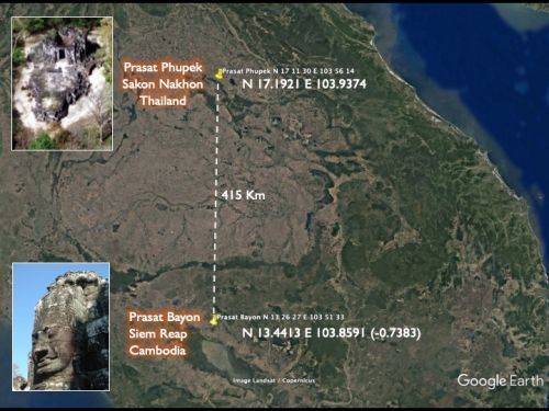
Prasat Phupek Thailand (N 17.1921 E 103.9374) and Prasat Bayon Cambodia ( N 13.4413 E 103.8591) are aligned at North and South direction

Prasat Phupek, Sakon Nakhon Province northeast of Thailand
Prasat Bayon, Siem Reap Province Cambodia
.jpg)
Formular for calculation of Earth's circumference between the two places, Thailand and Cambodia
Procedure
1. Team briefing at Come Hom Coffee Shop Sakon Nakhon prior to the D-day
2. Team B departed to Siem Reap Province Cambodia on 19 March 2012 and conducted shadow
measurement at Prasat Bayon at solar noon on 21 March 2012 (vernal equinox)
3. Team A at Prasat Phupek Sakon Nakhon Province Thailand conducted shadow measurement at the
same time of Team B at Prasat Bayon
4. the two teams exchanged result of shadow masurement via Facebook and Mobile Phone
5. Earth's circumference is calculated after collecting completed data
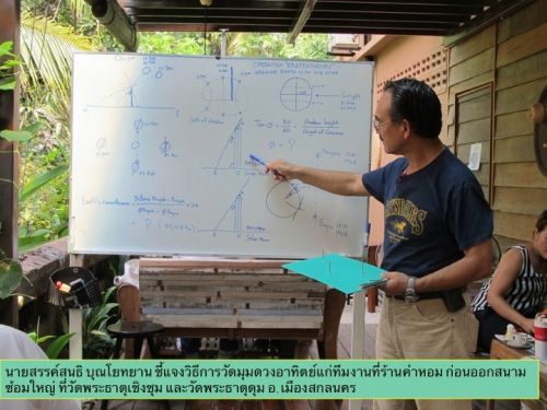
Team briefing at Come Hom Coffee Shop in Sakon Nakhon Province
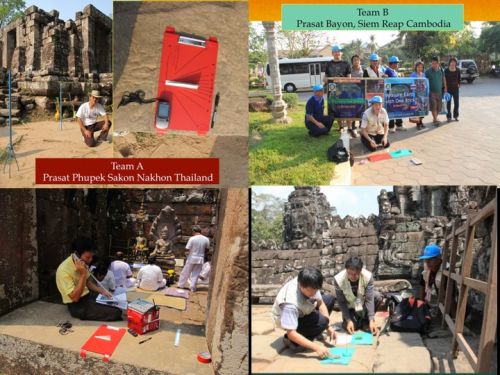
Team A and Team B in action ( in fact I am a lone rancher Team A at Prasat Phupek Thailand)
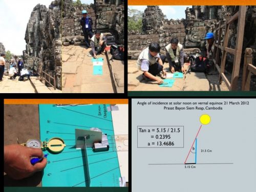
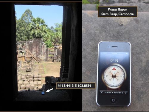
Shadow measurement by sundial at solar noon on 21 March 2012 by Team B at Prasat Bayon Cambodia yielded angle of incidence at 13.4686
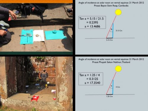
Angle of incidence at solar noon on 21 March 2012 at Prasat Bayon = 13.4686 and Prasat Phupek = 17.3540
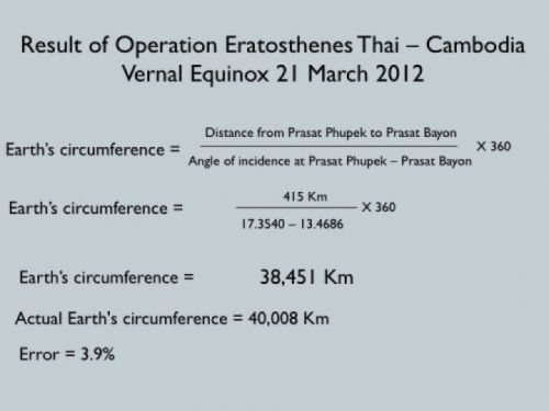
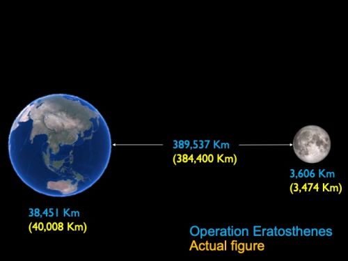
Result of Operation Eratosthenes, Earth's circumference = 38,451 Km with 3.9% error from the actual figure 40,008 Km

The main reason to conducted Operation Eratosthenes on vernal equinox 21 March 2012, because It is very easy to find angle of incidence at solar noon since the sun's shadow is straight-line for all day
Operation Eratosthenes Episode II
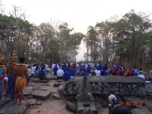
Vernal Equinox 21 March 2019
Operation Eratosthenes to measure Earth's circumference with one stick at Prasat Phupek Thailand is repeated on vernal equinox 21 March 2019
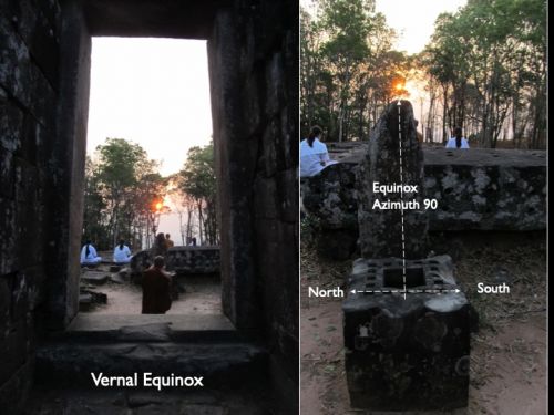
Prasat Phupek is an ancient Khmer temple believe to be built during the rein of King Jayavarman VII (1180 1220 AD), this temple is located on mountaintop of +520 m above sea level and oriented to astronomical direction known as equinox (azimuth 90) in order to aligned with the sunrise on new year of Saka Calendar (1st Chaitra month)
.jpg)
Prasat Phupek is located on the mountaintop of +520 m above sea level
.jpg)
Sunrise at due east of Prasat Phupek
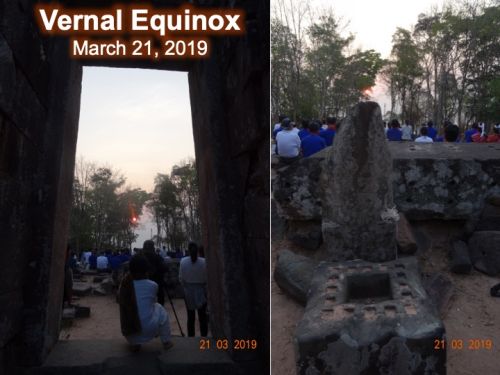
Equinoctial sunrise at Prasat Phupek Sakon Nakhon Province Thailand
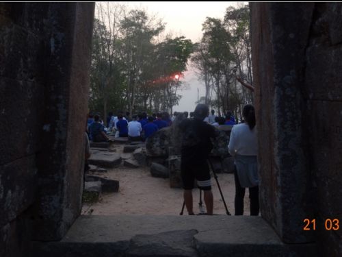
Today is first day of Chaitra Month of Saka 1941 (modern day 21 March 2019)
.jpg)
The morning sun is positioned at due east or azimuth 90
If the ancient Khmer Governor were here today he must have seen this scenario
.jpg)
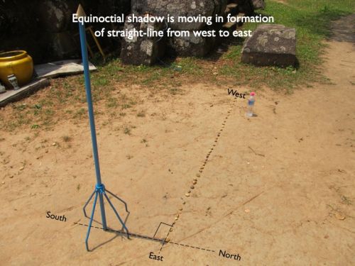
Vernal Equinox is an astronomical phenomena that sunlight fall at right angle at equator of the Earth, and hence day and night are equal, it is the beginning of spring season in the northern hemisphere and fall season in the southern hemisphere
Astronomical phenomena on vernal equinox 21 March 2019
1. Sun rises at the due east (azimuth 90), sun sets at due west (azimuth 270)
.jpg)
2. The sun's shadow from sunrise to sunset of any object is casted from west to east in formation of straight-line
.jpg)
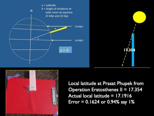
3. Angle of incidence of the sun's rays at solar noon is equal to the degree of local latitude
.jpg)
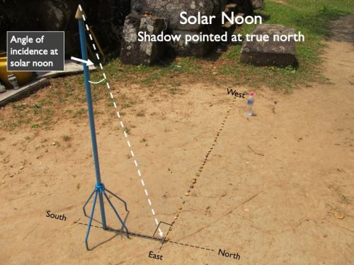
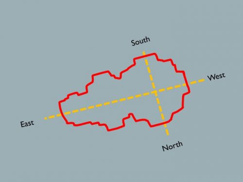
4. Shadow at solar noon is perpendicular to the East - West direction and pointed at true north
Procedure of Operation Eratosthenes Episode II, 21 March 2019
This is a repetition of the Operation Eratosthenes Episode I
1. Prasat Phupek in Sakon Nakhon Province Thailand and Prasat Bayon in Angkor Thom Siem Reap Province Cambodia are again selected for this experiment

2. Applying Eratosthenes's equation to calculate Earth's circumference on vernal equinox March 21, 2019, today shadow of the object is straightline from morning to evening so it is very convenient to determine angle of incidence at solar noon.
.jpg)
3. Calculation of angle of incidence at Prasat Phupek
4. A horizontal sundial is used to determine an angle of incidence at solar noon
.jpg)
5. Today is vernal equinox, hence the shadow of sundial is straightline from morning to evening. So it is very easy to find angle of incidence at solar noon by drawing a line from tip of the shadow to match perpendicular (90 degree) with the north-line (solar noon). Then angle of incidence of solar noon is determined by tangent of shadow's lenght and height of the sundial, here we have 17.354 degree
.jpg)
.jpg)
.jpg)
.jpg)
6. Referring to the "Operation Eratosthenes Episode I" on 21 March 2012 at Prasat Bayon Angkor Thom Siem Reap Province Cambodia, we got 13.4686
.jpg)
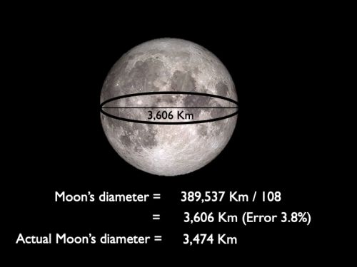
7. Calculated Earth's circumference is 38,451 Km with error 4% from the currently acepted polar circumference 40,008 Km
.jpg)
.jpg)
.jpg)
.jpg)
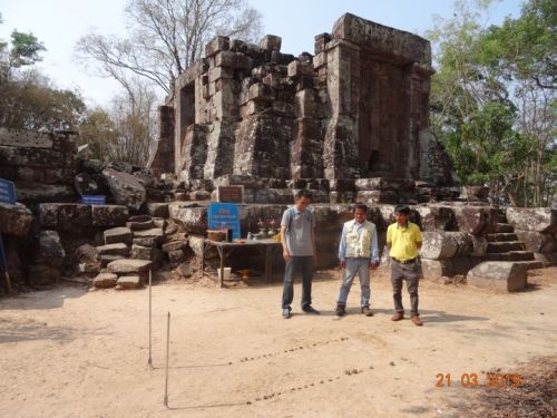
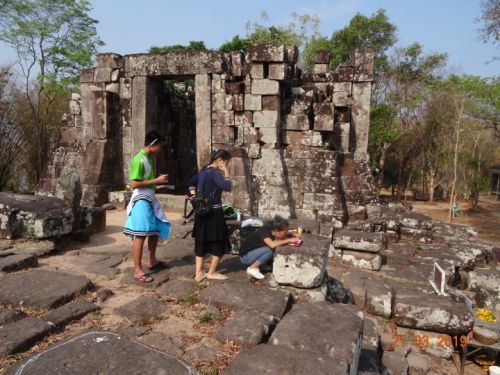
8. Big thanks for my co-working team, the two young science teachers from Sakonraj-wittayanukul school, MS. Cholruecha Kasaraj and MS.Sukanya Waraput their hard working under the hot sun yielded very satisfactory result
.jpg)
.jpg)
.jpg)
These two papers are their work-sheet
.jpg)
.jpg)
"Equinocial Temple" ....... Why and how?
People always asked why and how the ancient Khmer built this temple to aligned accurately at "equinox" (azimuth 90). The most simple answers are
1. Why ........ Saka Calendar was introduced to the ancient Khmer culture as part of indianization, and here vernal equinox is designated as first day of "chaitra month" literally an ancient Khmer new year. Normally some kind of the sacred rituals are performing that is the reason why many ancient Khmer temples are oriented to equinox
.jpg)
New year of Saka Calendar falled on vernal equinox designated as first day of Chaitra Month (currently March 21 or 22 on civil calendar)
.jpg)
The equinocial sunrise is seen at the center of east gate
2. How the temple is oriented accurately at equinox? ......... the most simplest way is a method called "shadow plot" Practically it can be done on any day but the most favorable is on 21 March (vernal equinox) and 23 September (autumnal equinox) due to the sun's shadow is casted in formation of straight-line from west to east
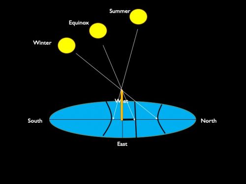
Formation of the sun's shadow at different season (noticed that the shadow on equinox is straight-line)
It is highly possible that "shadow plot" was deployed to find the 4 astronomical cardinals (North - South - East - West)
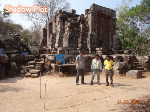
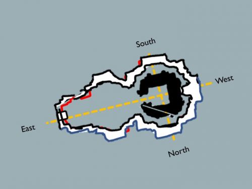
Demonstration of shadow plot was conducting at Prasat Phupek
Started in the morning by continue marking the tip of shadow with small stones till late afternoon or evening, finally the formation of shadow will be straight-line from west to east
.jpg)
.jpg)

Then north - south line is drawn at 90 degree against the east - west line
.jpg)
Out-line of the temple plan is drawn in accordance with the 4 cardinals
Then the actual construction is undertaken following the out-line
Operation Eratosthenes had opening the door to more astronomical experiments
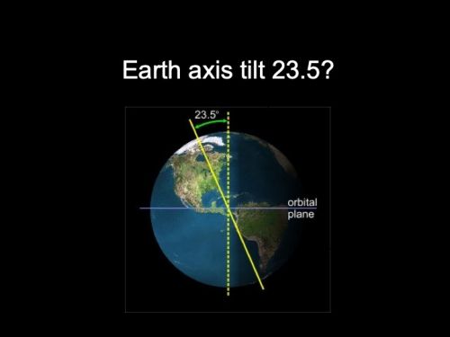
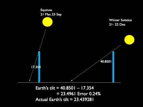
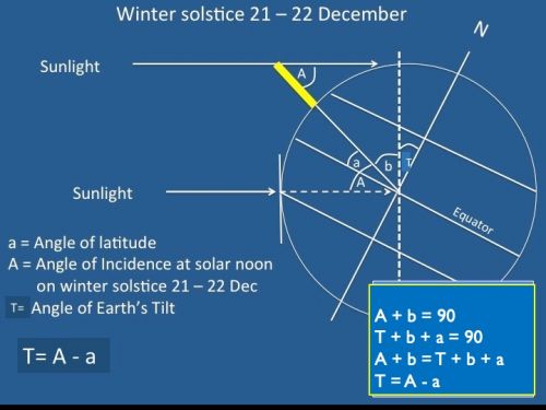
1. Does Earth's axis tilt is normal at 23.5?
It can be done by subtracting angle of incidence at solar noon on winter solstice with the local latitude
.jpg)
A vertical sundial is installed on the wall of Prasat Phupek on winter solstice 21 December

A vertical sundial at Prasat phupek
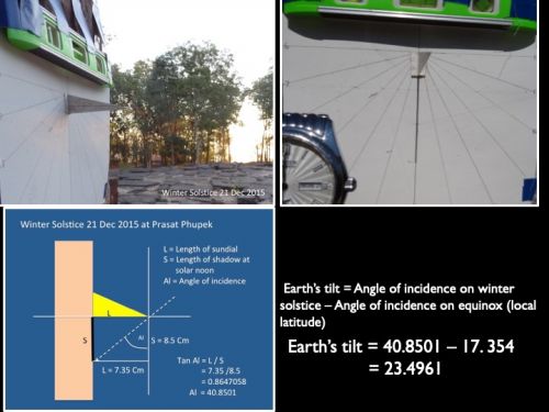
Earth's axis tilt is calculated by subtracting angle of incidence at solar noon on winter solstice with local latitude
.jpg)
Astronomically speaking the local latitude is the same as angle of incidence at solar noon on equinox (21 March and 23 September)
 T
T
The equation of Earth's axis tilt on winter solstice
2. Earth rotation ....... how fast?
Since Earth's circumference from operation Eratosthenes is 38,451 Km
.jpg)
Speed of Earth rotation is calibrated by sundial and clock at Prasat Phupek
.jpg)
.jpg)
Solar time and clock time should be corresponding to each other, that means one hour of the sundial should be the same as one hour of the clock. This experiment is conducted on winter solstice 21 December 2017
.jpg)
.jpg)
According to the equation of time; solar time on the date 21 December is slower than clock time about 2 minutes
.jpg)
.jpg)
Since solar time and clock time are corresponded to each other therefor speed of Earth rotation = Earth's circumference (Km) / 24 Hr
.jpg)
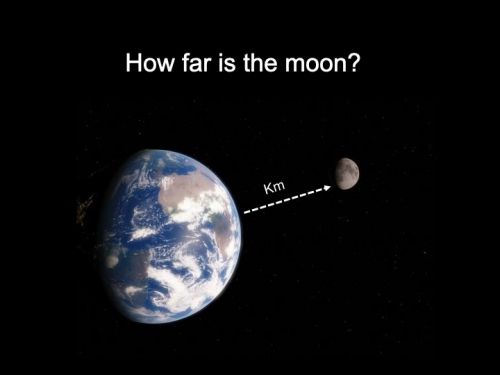
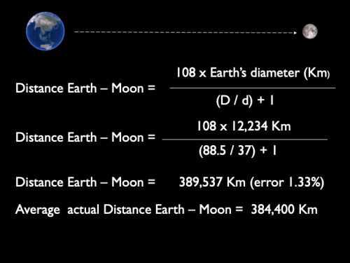
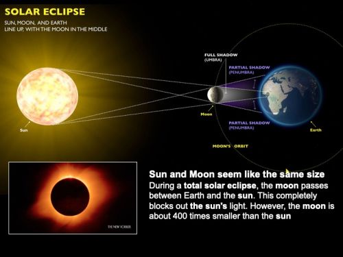
3. Measuring distance from Earth to moon
Can you calculate how far is the moon with one photo of lunar eclipse?
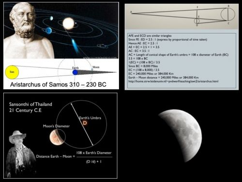
Over two thousand years ago an ancient Greek astronomer name "Aristarchus" had invented a method to calculate Earth - Moon distance by counting the time phases of total lunar eclipse. His ancient methodology is now modified to more simple calculation with only one photo of the total or partial lunar eclipse. The new calculation is called "Rahu Equation"
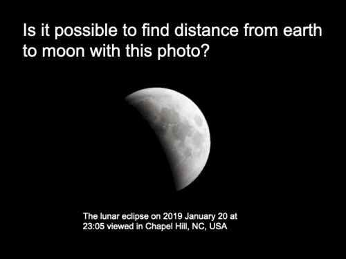
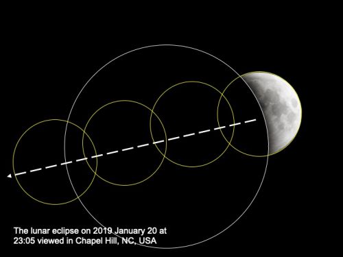
Earth's umbra and moon's diameter are created with the help of PowerPoint
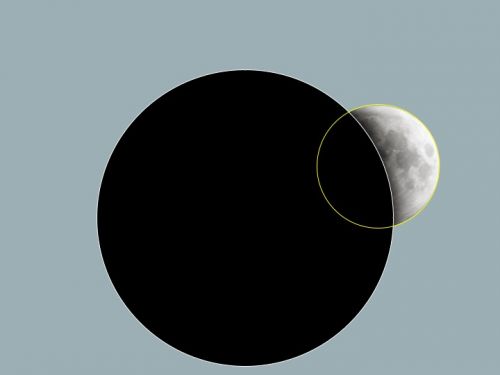
Diameter of both circles are measured and here we got Earth's umbra (D) = 88.5 unit, Moon's diameter (d) = 37 unit
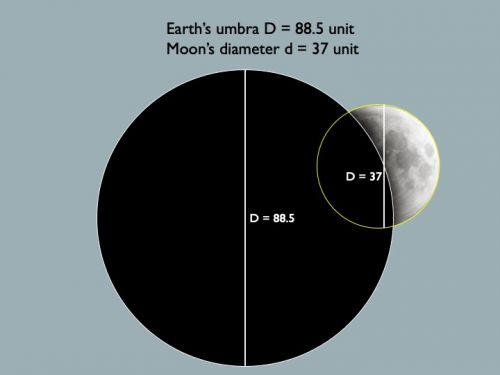
Apply the modified Aristarchus formulation called "Rahu Equation" to calculate distance Earth - Moon

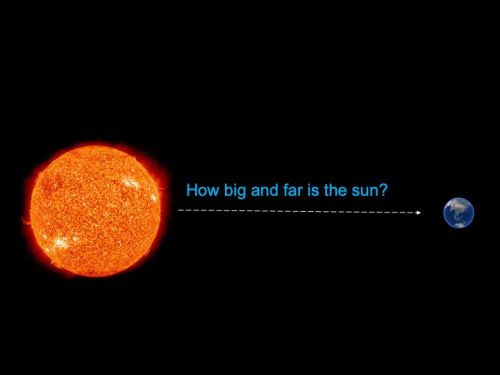
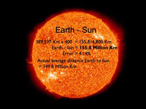
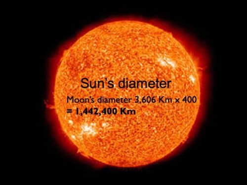
4. How far and how big is the sun?
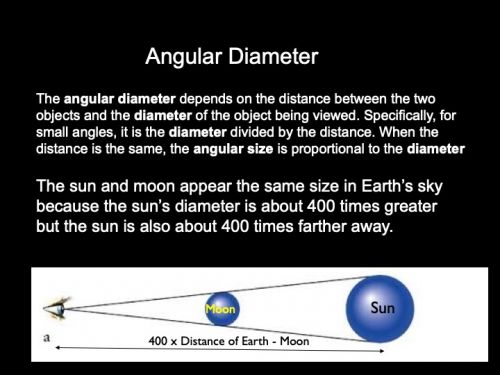
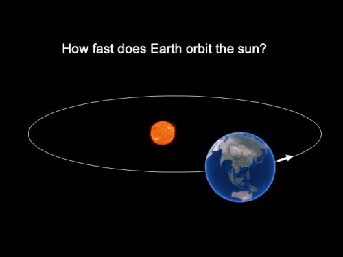
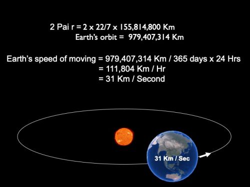
5.What is the speed of Earth moving aroun the sun?
Conclusion
Earth's circumference obtained from Operation Eratosthenes served as mathematic foundamental for other 5 astronomical experiments


